Top 8 Spectrum Considerations for Littoral Stand-in-Forces


marine forces

Worldwide marine corps/maritime infantries must be ready to operate within an enemy’s weapon engagement zone (WEZ) in littoral environments, conducting deep maritime reconnaissance while also maintaining stringent Emission Control/Signature Management (EMCON/SIGMAN) protocols. The US Marine Corps, through its Force Design 2030 and recent Concept for Stand-in-Forces highlights this plainly. Additionally, the UK Royal Marine Commandos through their Future Commando Force initiatives are refocusing efforts to support UK Littoral Response Groups with small and agile raiding teams, who are also tasked with maritime reconnaissance.

For these specialized units to accomplish their mission essential tasks, attention must be paid to the electromagnetic spectrum. Therefore, below are some considerations for these forces working inside a contested littoral electromagnetic spectrum, built from CRFS experience deploying systems within maritime and coastal environments.

site-spectrum1. Ensure Persistent Spectrum Baselining within the Littorals

Before any boots are on the ground, spectrum managers and CEMA teams should baseline the spectrum across the area of responsibility (AOR) and assist operators with their communications planning (aka a PACE plan) before they deploy.

As seen in recent conflicts, such as in Ukraine, the spectrum allocation plan goes out the window once combat operations commence as they are not able to rapidly flex as new signals/users enter the AOR. Therefore, units deploying from their home station might have constructed a PACE plan that is not reflective of the contested RF environment. More simply put, what they thought was an allocated channel, might turn out to be one filled with interference from multiple users (both friendly/enemy military or civilian).

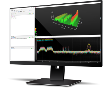
CRFS has a range of deployable, compact, and incredibly sensitive expeditionary RF receivers. Our RFeye receivers are passive and can be networked through multiple means, including low emission communications methods such as point-to-point datalinks. Operators can cover from 9kHz up to 40GHz with 100MHz instantaneous bandwidth (IBW) for total command of the spectrum.

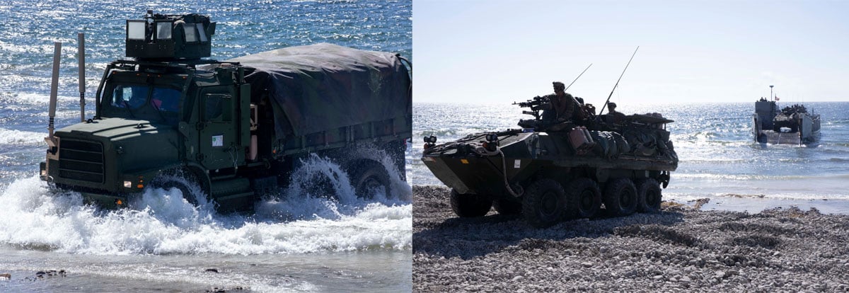
Pre-positioning CRFS RFeye nodes at critical maritime chokepoints, Seaborne Points of Departure/Arrival (SPODs) and Airborne Points of Departure/Arrival (APODs), would allow communication officers to compare their PACE plan to the current spectrum environment prior to deployment. Operators can also overlay spectrum allocation plans (both military and civilian) from CSV files into the RFeye Site software as well as easily conducting occupancy measures.

mission-planning-400x402
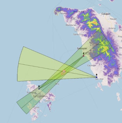
2. Conduct Robust Mission Planning and Experimentation for Optimal Signal Collection
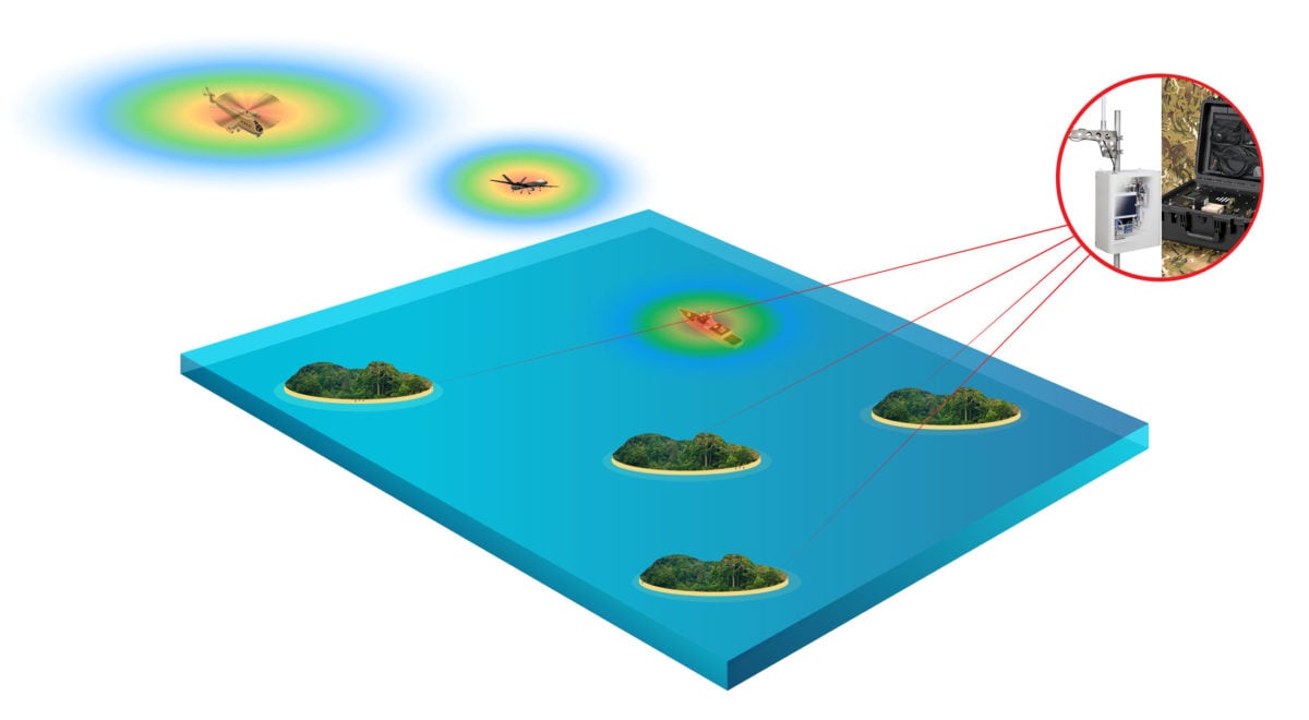
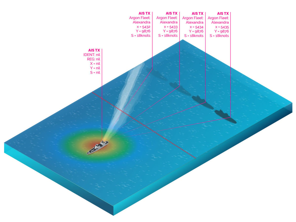
Now that a spectrum baseline is known, mission planning can follow. RFeye site software brings an incredible and realistic simulation capability directly into the hands of CEMA planners, from the squad level to the joint headquarters. The simulation tools enable testing of RFeye node placement against transmitters (including PSK, TETRA, CW, GSM, and more) and further incorporate propagation models. LiDAR models can be imported into the simulation to give a highly accurate view of the terrain. In addition, the simulated transmitters can be either fixed or made to move along a pre-determined path. Line of sight propagation analysis assists also with positioning point-to-point datalinks during larger system deployment. Lastly, all geolocation methods can be simulated including TDoA, AoA, and PoA. With CRFS, pre-mission planning within the spectrum has never been easier and more precise!

3. Execute Layered Airborne and Maritime Reconnaissance

Once in theater, a key task of Stand-In-Forces is to provide long term persistent surveillance using a range of available sensors. Proficient control of the electromagnetic spectrum allows for many intelligence possibilities, from intercepting voice transmissions to tracking ship and airborne movements from their RF emissions (radar, data links etc.). This ability to identify multiple protocols and signals enables CEMA teams to fulfill commanders critical reporting requirements all the way up to the national level.

Using a network of CRFS receivers, RF transmissions can be detected and geolocated with a high level of accuracy, from many hundreds of miles away, via multiple methods. This data can then be used to build up a pattern of life, assess adversary vulnerabilities and create options for future operations.

The CRFS passive detection and awareness system (such as 3D TDoA) can be used to cue other systems such as air defense radars. By allowing air defense operators to only turn on air defense radars for terminal tracking/engagement, they can make it harder on the enemy to detect it.

Layered Airborne and Maritime Reconnaissance

Stand In Forces on islands using TDOA to geolocate targets from their RF emissions.

4. Fight Through and Attribute GPS Jamming

Stand-In-Forces are likely to face GPS interference/jamming threats inside a contested battlespace. That is why CRFS developed a GPS holdover device that offers hours of GPS holdover for each RFeye Node. This holdover ensures geolocation missions can continue to provide critical operational data in GPS denial areas. In addition, the receivers can also geolocate the source of the jamming/spoofing signal, assisting in rapid GPS jamming attribution through standardized interference reporting processes (like the US Joint Spectrum Interference Resolution process).

5. Uncover Maritime Deception and Spoofing

Prior to a littoral conflict, enemy forces might attempt insertion using deceptive measures within the Electromagnetic Operating Environment (EMOE). One example could be AIS spoofing to mask their actual position vice their reported position. This type of deception occurred within the Black Sea against NATO vessels, and in the Pacific, as the North Korea vessels have engaged in AIS spoofing to avoid sanctions. Here, a CRFS TDoA system can geolocate the AIS vessel transmission and compare it to the reported AIS message location transmitted in the metadata. The variance level can be manually set, and RFeye Site will alarm the user if the variance is outside normal parameters. Once the spoofing is detected, this information can be used for follow-on effects or as sanction enforcement evidence. Learn more about AIS spoofing detection here.

Naval Frigate spoofs its position to outside contested waters.

Naval Frigate spoofs its position to show it is outside contested waters, or to mislead opposition forces.

6. Protect Expeditionary Airfield/FARP Critical Communications

As marine, air, or special operations forces establish Forward Arming and Refueling Points (FARP) on remote islands inside a contested EMOE, airfield spectrum monitoring and protection becomes critical. Air Traffic Controllers must ensure their ground-to-air frequencies are protected, deconflicted with any civilian transmissions, and swiftly execute their PACE plan if jamming or interference is detected. Also, to establish a cooperative air picture around the FARP, ADS-B decoding and geolocation can be included. Read more about ADS-B detection, geolocation, and spoofing.

 marine-landing

7. Incorporate Realistic EMCON Training and PACE Verification

The “era of white carding” electronic warfare effects during training exercises is over. To truly train operators on Electronic Protection (and specifically EMCON/SIGMAN) they must run the gauntlet against RF sensors that replicate near-peer SIGINT/EW capabilities. Because CRFS systems are not built with sensitive storage, and are top-end COTS gear, marine forces can use them for EMCON training with partners and allies and simulate complex detection threats.

Deploying flyaway kit such as RFeye Stormcase or the long-duration IQ recording SenS Portable solution, can greatly aid platoon level to brigade level training events. RF events can be replayed directly afterwards to demonstrate a unit’s ability to execute solid PACE/EMCON measures including: electronic masking, wartime modes, tactical deception, and more. Add multiple RFeye nodes for TDoA/AoA replication and geolocation.


8. “In any Clime or Place” the CRFS Tailored Approach

CRFS understands that stand-in-forces will likely require custom gear and unique deployment methods to deal with harsh environments where the land meets the sea. This is exactly why CRFS RFeye Nodes can be installed on multiple platforms and are rated for varied temperatures and weather conditions. From vehicles to boats, in expeditionary Stormcases, or in rugged IP66 outdoor covers for more enduring missions, CRFS works directly with the operators to tailor the fit.

Conclusion

Littoral operations are inherently complex, and so will be the electromagnetic spectrum that covers it. It is time for operators to know that solutions exists to help them fight and win during all phases of operations, from mission planning to execution.

Interested in learning more, observing the software in action, or speaking about how CRFS can help littoral forces control the electromagnetic spectrum? Please do not hesitate to contact us.

The appearance of U.S. Department of Defense (DoD) visual information does not imply or constitute DoD endorsement.

Zac George

Zac George is the International Business Development Manager for CRFS. He is a former naval Electronic Warfare officer and also has experience in digital decoding. He speaks regularly on EW and spectrum topics globally, and lives in Switzerland.

Get instant news & expert insights

Join thousands of professionals who subscribe for exclusive insights and early access to our reports and analysis.

Subscribe now