Spectrum Monitoring for Unmanned Surface Vessels (USV)


The use of Unmanned Surface Vessels (USV) is becoming more widespread, and the removal of humans onboard brings many productivity and tactical advantages. However, USVs are now fully dependent on critical communications pathways for command and control (C2) using the electromagnetic spectrum. In this blog, we observe how USVs use the spectrum for communication and spectrum awareness, the electromagnetic threats they face, and how these threats can be mitigated.

The market for Unmanned Surface Vessels (USV) is growing at a rapid rate. According to a recent report, the market is “expected to reach $165.61 billion by 2030”1. After the impacts of COVID-19 on the maritime shipping industry, some industry leaders see USVs as insurance against another logistical nightmare caused by quarantine requirements that force ships to wait for weeks and months outside ports. Navies around the world are also looking to supplement manned vessels with unmanned, specifically within the Submarine Hunting, Oceanography, and Intelligence Collection mission sets. This is all in an effort to increase endurance, efficiency, and remove human error factors from navigation.

The Sea Awash with Spectrum

Vessel control ranges from fully autonomous (AI) to human control, albeit remotely from a shore station or USV mothership. However, they all need some sort of awareness of their environment. This is accomplished through a myriad of onboard sensors, including critical communication links, radars, and optical sensors amongst others. Communications pathways range from VSATs (Ku-Band), Wi-Fi, to other marine networks.

usv-test-craft-1200x675

Typical RF spectrum devices used by USVs

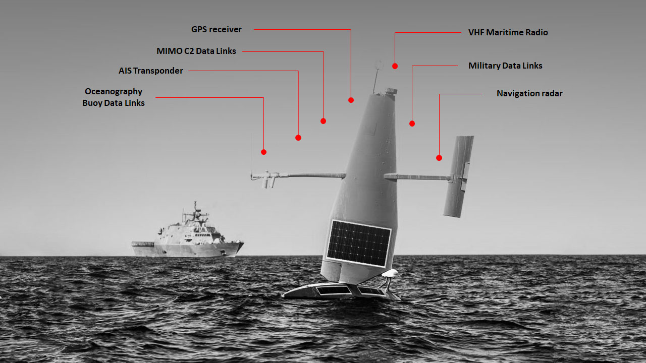
Within a military context, multiple pathways can be used when employing USVs in a “swarm” configuration, with more tactical USVs communicating with a larger USV mothership, that connects back to shore. Additionally, communications can also occur between USVs and airborne/undersea drones, further complicating the spectrum.

When these pathways are placed within a littoral contested electromagnetic spectrum, the risk of jamming/interference rises, ultimately resulting in “lost link” collisions. While naval spectrum managers can ensure that communication frequencies are deconflicted, the enemy always gets a vote, meaning that during combat operations, especially within littoral environments, jamming and friendly interference creates a very high risk for USV operations.

Another danger to USV’s is AIS spoofing and GPS spoofing.  Without a human onboard to verify the vessel’s location manually, spoofing could confuse or cause a USV to veer off course and create collisions, groundings or stray into another country’s territorial waters.

Monitoring and Mitigating Spectrum Threats

To deal with any potential risks to communication pathways, you first need to know what is happening with the electromagnetic spectrum. An RF receiver (such as an RFeye Node) on board the USV can provide detailed information on spectrum utilization. What is being transmitted, on what frequencies, and when? This can be further enhanced by overlaying military and civilian spectrum plans on top of real spectrum, as you can with the RFeye Site software.

The spectrum information can be time-stamped and stored on board for later retrieval or transmitted in real time to headquarters ashore/mother ship. If a signal was detected, such as a GPS jammer, then an alert can be sent to ensure the safety of the USV and other naval assets. To ensure robust operations in highly contested spectrums, CRFS Nodes can be used with more jam-resistant communications to ensure backhaul connectivity to shore is strong.

Adding Geolocation

While basic spectrum data forms part of the intelligence picture, it doesn’t say where the jamming originated from (attribution).  To do this, a network of three or more Nodes would be needed to perform Time Difference Of Arrival (TDOA) geolocation. The three Nodes could be installed either on multiple USV or a combination of USV, manned vessels, Unmanned Aerial Vehicles (UAVs), or shore infrastructure. Think about it…unmanned air, seaborne, and ashore Nodes all feeding RF geolocations into a Recognized Maritime Picture (RMP) via a TCP/IP data (or ASTERIX) streaming capability. Jamming detected and attributed quickly.

usv-map-propogation

4x USVs equipped with CRFS Nodes on 10-meter masts could cover 70km, approximately 4900Km2 (simulated in RFeye Site Software against a 30 dBm signal at 1 GHz at 10 Meters height)

usv-map2

A signal of interest being geolocated by a combination of USV and shore-based receivers


Operationally ready

This isn’t just conjecture, this is reality. Our proven TRL9 RFeye Nodes have been installed on a variety of maritime vessels delivering spectrum awareness, signals intelligence and fleet protection. If you are looking to deploy USV’s speak to us first and see how we can help protect your communication pathways and deliver enhanced intelligence.

Contact us below so we can schedule a short exploratory call so you can see how the system works and how it could benefit your USV fleet.

1. https://www.alliedmarketresearch.com/press-release/autonomous-ships-market.html

Zac George

Zac George is the International Business Development Manager for CRFS. He is a former naval Electronic Warfare officer and also has experience in digital decoding. He speaks regularly on EW and spectrum topics globally, and lives in Switzerland.

Get instant news & expert insights

Join thousands of professionals who subscribe for exclusive insights and early access to our reports and analysis.

Subscribe now