Make site selection and installation more accurate with fine-tuned propagation analysis
Manually setting up and testing receiver networks piece by piece can quickly grow tedious. First, sites must be pre-selected for sufficient line of sight and networkability. Next, fiber lines must be run, or mesh networks set up, and then each receiver must be brought online and tested for connectivity and signal reception.
Our digital propagation analysis module minimizes these headaches.
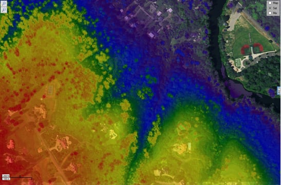
CRFS continuously refines this tool and the underlying propagation models with new capabilities. The latest capability is the import of custom elevation models such as LIDAR (light detection and ranging), which gives a resolution as detailed as 25 cm and enables detection of tree canopy.
The RFeye propagation tool allows the overlay of various data models to build up the most accurate picture of propagation based on the available data. At its most simple, the free space model of propagation is used which only considers attenuation of RF signals. Earth Curvature takes this further by also allowing for horizon effects while Line Of Sight (LOS) and Fresnel models include effects of obstacles. LOS only considers shadowing effects while Fresnel also includes reflection and diffraction modelling.
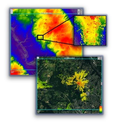
The accuracy and precision of this propagation modeling depends on the resolution of elevation data used. By default, SRTM (Shuttle Radar Topography Mission) data with a minimum resolution of 30 m is used. This ignores the smaller details in elevated structures such as mountains, as well as completely missing details such as tree canopy.
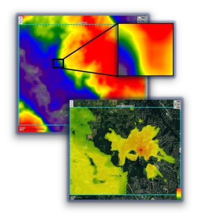
The capability to import custom elevation models in RFeye software allows further refinement of the propagation model. LIDAR data with resolution as detailed as 25 cm can be imported for example, providing detailed models of terrain elevation and enabling detection of tree canopy.
The two sets of images below showing SRTM and LIDAR elevation data and the resulting propagation maps demonstrate the importance of precise elevation models for accurate propagation analysis.
Top to bottom: SRTM elevation map with detailed view; Corresponding coverage map
Top to bottom: LIDAR (0.5 m resolution) elevation map with detailed view; Corresponding coverage map
We can clearly see the enhanced level of detail for the LIDAR elevation data on the right compared with the SRTM data. In this case, a network designed on the basis of the SRTM data would result in an insufficient number of receivers being installed.
Using the more precise elevation data of LIDAR allows the network planner to avoid both under-design (insufficient coverage) and over-design (unnecessary cost) of the network.
Still further refinement of this modelling can be gained by adding user defined RF objects with material-specific propagation losses.