DF & GEOLOCATION

Counter threats by detecting, classifying, and locating signals of interest over a wide area

Overview

RF direction finding and geolocation techniques provide the critical insights needed for effective decision-making. Knowing a transmission exists is important, but knowing the location of that transmission can deliver vital intelligence for both military and civilian applications. 

Direction Finding (DF) provides a bearing to a transmission by using an angle from the sensor to the transmitter. Conversely, Time Difference of Arrival (TDoA) geolocation pinpoints the precise geographic coordinates of a transmission in two or three dimensions.  

  • Geolocate the source of a signal

  • Time Difference of Arrival (TDoA - 2D & 3D)

  • Power on Arrival (PoA)

  • Angle of Arrival (AoA)

DF & geolocation applications

Military-EMSO-icon-1
Military spectrum monitoring & EMSO

CRFS technology helps military operators dominate the spectrum by identifying and locating threats and turning real-time signal capture and emitter data into actionable intelligence. 

Drone-defense-icon
Defense against unmanned aerial vehicles (UAVs)

RF monitoring systems detect and geolocate military and modified UAVs in real-time using techniques such as triangulation and multilateration, to help respond to threats swiftly. 

Interference-hunting-icon
Locating sources of RF interference

To pinpoint the direction of an interfering RF signal, sensors measure the time delay of the received signal at each antenna and triangulate the signals source location.  

Border-icon
Border security monitoring

By precisely determining the location of a threat and then monitoring enemy communications, military forces can respond rapidly to incidents in border areas. 

civil-aviation-icon
Aviation & aviation safety

By tracking the positions of aircraft, controllers can ensure safe separation and correct use of airspace. 

search-rescue-icon
Search & rescue operations

DF technology helps locate distress signals from emergency beacons used by aircraft and ships. 

Data-for-prosecution
Law enforcement & security

DF and geolocation can help security agencies locate the sources of suspicious or unauthorized communication, aiding in counterterrorism efforts and criminal investigations. 

space-icon
Spaceport asset protection

Geolocation techniques are used to track the positions of spacecraft and satellites, ensuring accurate communication and navigation during space missions. 

Talk to an advisor about DF & geolocation

DF & geolocation expertise

WP-Cover-Soectrum-monitoring-geolocation
Spectrum monitoring & geolocation systems

An overview of contemporary radio spectrum monitoring practice and the sensor and geolocation technologies required to meet emerging challenges.

WP-Cover-AoA
Angle of arrival / direction finding techniques
How does AoA work? How can it be applied in practice? And how can it be combined with other geolocation techniques such as time difference of arrival (TDoA)?
WP-Cover-Principles-of-geolocation
Principles of geolocation techniques
This white paper describes the underlying principles of geolocation techniques (AoA, TDoA, FDoA, & PoA) and outlines their applications.
DETECTION & 3D GEOLOCATION OF AERIAL TARGETS OVER WIDE AREAS
REAL-TIME DIRECTION FINDING  & FULL SPECTRUM AWARENESS
INCREASING LINE OF SIGHT & GEOLOCATING GROUND-BASED  TARGETS FROM A LONG DISTANCE
DEPLOYMENT STORIES
DETECTION & 3D GEOLOCATION OF AERIAL TARGETS OVER WIDE AREAS

How a NATO partner built an air defense platform to increase national security 

Read the story
DEPLOYMENT STORIES
REAL-TIME DIRECTION FINDING & FULL SPECTRUM AWARENESS

How a Southeast Asian government intelligence service secured multiple borders.

Read the story
DEPLOYMENT STORIES
INCREASING LINE OF SIGHT & GEOLOCATING GROUND-BASED TARGETS FROM A LONG DISTANCE

How TEKEVER & CRFS collaborated to fit UAS with ultra-sensitive RF receivers as a payload.

Read the story

Related reading

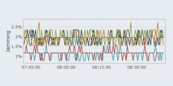
How to address GPS jamming in high-jamming environments
by Jaimie Brzezinski
Modern navigation is as dependent on an accurate GNSS feed as Columbus was on his compass. The eastern Mediterranean, Black Sea, areas of the Baltic, Poland, and parts of ...
Passive air defense: geolocating airborne targets using detector-based 3D TDoA
by Jon Bradley
While radar is a widespread and versatile tool for detecting and locating in the battlespace, it has a critical Achilles heel. As active systems, radars have their own EMS ...
Geolocation techniques for RF border surveillance in remote areas
by CRFS Marketing
International borders are prime targets for criminal activity, with weapons, drugs, and even humans being smuggled between countries by land, sea, and air. Border protection ...